

L'analyse historique des îles Senkaku Japon
If you put "Senkaku Okinawa Ching" or "Senkaku Okinawa Ming" into English Google "Web" Search, you would surely find "EEE-Reporter" in the first or second result page.
Or, if you put "Senkaku Okinawa" into English Google "Images" Search, you would surely find some images presented in "EEE-Reporter" in the first result page.
So, the past posting related to the Senkaku History (first created on Oct. 24, 2010) is here revised.
Historical Analysis on the Senkaku Islands (Ver. 10-2)
(Please set the Encode in Page menu of your browser at Unicode to correctly read Kanji characters used below.)
First of all click the following map (The New York Times should see that Yonakuni Island and the Yaeyama Islands are also part of Okinawa Prefecture as China and Taiwan have never made an objection in the past).
The Senkaku Islands are closer to the Chinese Continent than to the Main four Japanese islands; but the Senkaku Islands are far closer to Japan's Okinawa islands than to the Chinese Continent. The Senkaku Islands are clearly part of Okinawa Prefecture of Japan as the following map indicates.

The difficult part to understand is mostly between past China and past Okinawa rather than between present China and present Japan. Specifically, the Senkaku issue rests on relationships between the Ming and later the Ching Dynasties and the Okinawa (Ryukyu) Kingdom which is however now Okinawa Prefecture, Japan.
Now, the oldest human bones found in Okinawa Prefecture are of 32,000 years ago and then of 18,000 years ago.
The oldest record of Okinawa people visiting Japan's Imperial Court in Yamato (Nara), south of Kyoto, is of A.D. 714.
More clearly, a group of Japanese people with agriculture skills moved to Okinawa islands from Kyusyo, one of the major four islands of Japan (called Japan proper), as late as the 10th century. Since then, the Okinawa (Ryukyu) people moved around from the main Okinawa island to the Yaeyama Islands including Ishigaki Island, Iriomote Island, and Yonakuni Island.
They frequently sailed around the Senkaku Islands partly due to the ocean current flowing north from the Yaeyama Islands to Senkaku. As the above map clearly indicates, the Senkaku Islands are too far for fishermen living coastal ares of mainland China, while Taiwan indigenous people had no skills or customs sailing around north on the East China Sea, before modernization.
But, if you have any doubts on Japan's Senkaku, check the related history below presented.
1274: The Yuan Empire of China, a successor of Genghis Khan's Mongolian empire, launches war against Japan, for Japan governed by the Hojyo samurai clan refused to be subject to the Yuan emperor. So, Yuan of Mongolians dispatches 30,000 troops to Japan through the Korean Peninsula; they are however destroyed when landing on northern Kyusyu partly due to a typhoon called "kamikaze" and mostly due to courageous samurais. All the survivors of the Yuan troops fled back to the Chinese Continent over the sea.
1281: The Yuan Empire this time mobilizes 40,000 troops for a route from the Korean Peninsula and 100,000 troops for another route through the East China Sea to northern Kyusyu. They are however destroyed when landing on northern Kyusyu partly due to a typhoon called "kamikaze" and mostly due to courageous samurais. All the survivors of the Yuan troops fled back to the Chinese Continent over the sea.
(Some Chinese today claim that the Yuan Dynasty occupied the Senkaku Islands as its own territory. But, the fact seems only that the Yuan fleets carrying 100,000 troops just sailed over the East China Sea to Kyusyu of Japan. And only a few could sail back after the failure in invading Japan proper or mainland Japan that includes the Kyusyu Island.)
The 14th Century: Japanese pirates called Wakou intensifies their activities attacking coastal areas of China facing the East China Sea as the figure below indicates.

http://en.wikipedia.org/wiki/Wokou
(Accordingly, for a Chinese Dynasty, it became more important to defend its coastal areas, residents, and subjects living there than to set any ineffective or nominal border on the surface of the East China Sea. So, official maps a Chinese Dynasty would draw should show a defence line rather than a border on the sea.)
1368: The Ming Dynasty is established in China by the Hongwu Emperor.
1372: King of Okinawa (also called Ryukyu) Satto brings a tribute to the Ming Empire.
1401: The then samurai king of Japan (shogun) Ashikaga Yoshimitsu also sends an envoy to the Ming Dynasty to establish diplomatic relationships between Japan and Ming for benefits of trade.
1404: The Ming Court acknowledges Yoshimitsu as King of Japan who is allowed to trade with Ming in the form of bringing goods as tribute and receiving gifts in return. (However, the emperor of Japan [called Ten-nou] has nothing to do with this diplomatic relationships. This title of King of Japan is not welcomed by noblemen around the emperor in Kyoto.)
To make clear the difference from the Japanese pirates, Japanese merchants authorized for the trade are obliged to carry a licence plate or a tally stick(called Kangoufu) each.
Till 1640's when Ming is replaced by Ching, Japan sends official envoys for trade total 19 times to Ming.
1404: The Yongle Emperor of Ming authorizes King of Okinawa as his subject to allow trade with Ming.
Till 1866, the Ming and then the Ching Dynasties have sent envoys to Okinawa total 23 times for an Imperial investiture to attest successive Kings of Okinawa.
Till 1879, the Okinawa Kingdom has sent official envoys for trade total 173 times to the Ming Court and then total 68 times to the Ching Court.
(Accordingly, only based on this record, it is apparent Okinawa people acknowledged naval, navigational, and diplomatic importance of the Senkaku Islands more than Chinese officials who wrote a report or a book with a description about the Islands. As no Chinese moved to the Senkaku Islands and no Chinese empires proclaimed the ban of use of the Senkaku Islands to Okinawa people, they did not take any measures to record their monopolized use of the Senkaku sea area.)
1405: The Ming Court starts to send a series of seven naval expeditions led by Zheng He (Tei-wa in Japanese) to reach Indochina, Indonesia, India, Iran, the Arabian Peninsula, and Somalia of East Africa. This naval project has continued till 1433. However, this historical voyage is not intended to directly occupy overseas territory but to persuade overseas nations to bring a tribute to the emperor of Ming like in the case of the Kingdom of Okinawa.
1534: An imperial envoy from the Ming Court called Chin-Kan (so called in Japanese, [陳侃]) writes an official report called Shi-Ryukyu--Roku (in Japanese, [使琉球録]) where he mentions some islands that are identified as part of the Senkaku Islands.
In this report, Chin-Kan describes it was after his ship with that Okinawa people on board (returning to mainland Okinawa) passed an island which was closer to mainland Okinawa than the Senkaku Islands that the Okinawa people showed great relief, as if they had returned to their home territory.
(So, China today claims that Okinawa people did not regard the Senkaku Islands as being within their territory, since Okinawa people did not show great relief when they saw the Senkaku Islands.
But, it is a very subjective remark and personal judgment by the envoy Chin-Kan himself. He was neither an emperor nor a minister with any authority to define the territory of the Ming Empire.)
1562: An imperial envoy from the Ming Court called Kaku-Jyo-Rin (in Japanese, [郭汝霖]) also writes a report ([重編使琉球録]) and mentions some islands that are identified as part of the Senkaku Islands in his official report. Kaku expresses the Senkaku Islands as a kind of border for the Ming Empire.
(So, China today claims that the Senkaku Islands were regarded as border islands on their side by the Ming Dynasty.
However, without officially recognizing the Senkaku Islands as their own, any Ming's envoy would mention the Islands in a report as a place critical to take note of for the defence. Especially, the Ming's defense was not against a subject kingdom of Okinawa but Japanese pirates. What was needed to be described is not a border but a defence line as it was described.
Before Ming's envoys first encountered the Senkaku Islands, Okinawa people had been sailing around the Islands, since they were great voyagers as far as to Japan proper and South East Asia.)
1562: Admiral Hu Zongxian or Ko-Sou-Ken (in Japanese, [胡宗憲]) of Ming issues a now-famous map called Cyu-Kai-Zu (in Japanese, [籌海図編]) prepared by scholar Tei-Jyaku-So (in Japanese, [鄭若曽]) where a sea area including the Senkaku Islands is specified as a kind of national defence line for Ming.
 (http://www.geocities.jp/tanaka_kunitaka/senkaku/chokaizuhen-1562/ )
(So, China today claims that the Senkaku Islands were regarded as border islands on their side by Ming.
However, in this map, an island, called Kei-Ko-San (in Japanese, [鶏籠山]) then regarded as belonging to Taiwan by the Ming Court in Beijing is also put down.
Accordingly, Japanese experts claim that this map does not exclusively include islands within the territory of Ming, since Taiwan then did not belong to the Ming Empire. Especially, the Ming's defense was not against a subject kingdom of Okinawa but Japanese pirates. What was needed to be described is not a border but a defence line as it was described.
The very rough map simply told that Ming officials came to know the Senkaku Islands through their diplomatic relationships with the Kingdom of Okinawa who would have never made an objection even if Ming's map had depicted the Senkaku Islands as if they had belonged to Ming, since Okinawa was diplomatically subject to mighty Ming at the time.
Otherwise, why should Ming's officials have had to sail 400 km off the continent to check the non-disputed Islands between mighty Ming and peace-loving Okinawa? As the Senkaku Islands are situated just 190 km to the nearest Okinawa island, it is rather assumed that Ming officials virtually tried to unlawfully take the Senkaku Islands from Okinawa. The map is useless before the right interpretation of history.)
1592 and 1598: The then samurai ruler of Japan Toyotomi Hideyoshi launches war with the Ming (partly because Ming treated Hideyoshi as subject King of Japan and proud Hideyoshi go angry), taking a route to Beijing through the Korean Peninsula, though this campaign with 100,000 and more samurai troops were terminated due to death of Hideyoshi of illness.
The Kingdom Okinawa joined this Hideyoshi's campaign on the logistics side.
1609: Samurai lord Shimazu in southern Kyusyu of Japan proper invaded Okinawa with 3000 samurai troops to establish its occupancy in Okinawa islands. The king of Okinawa however is allowed to survive as a subject to the Shimazu clan who is a subject of the samurai king (shogun) Tokugawa in Edo (Tokyo).
Since then, the Kingdom Okinawa was subject to both the Ming Court of China and the Shimazu clan of Japan.
1614: A regional official document of Jyugen (in Japanese, [壽源県志]) prefecture of the Ming is issued but does not include the Senkaku Islands as part of its territory, while Jyugen prefecture could cover the sea area near the Senkaku Islands as its administrative territory.
1644: The Ming Dynasty of the Han Chinese collapsed; the Ching Dynasty of Manchu was established in mainland China. As Manchu is traditionally from Manchuria or currently the north east region of China, the Ching Court in Beijing abolished or changed many Han customs and ways of administration.
1683: The Ching Dynasty officially takes Taiwan into its territory.
1684: The Ching Dynasty releases an official document ([福建通志]) on Fujian Province facing the East China Sea. In this document, the Senkaku Islands are not included in the administrative region of the Fujian Province government.
1717: An official document of Shora (in Japanese, [諸羅県志]) prefecture of Taiwan Province is released to define the north border of Taiwan at the Dai-Kei-Ko-San (in Japanese) Island which is in the south of the Senkaku Islands.
1718: An official document of Neitoku (in Japanese, [寧徳県志]) prefecture of Fujian Province is released but does not include the Senkaku Islands as part of its territory, while Neitoku prefecture could cover the sea area near the Senkaku Islands as its administrative territory.
1765: The Taiwan local government issues an official document called Zokusyudai-Taiwan-Fushi (in Japanese, [続修台湾府志]) where the north border of Taiwan is set at the Dai-Kei-Ko-San (in Japanese, [大鶏籠山]) Island which is in the south of the Senkaku Islands.
1838: The Ching Court issues an official document ([重纂福建通志福建海防全図]) with an attached map named the Fujian Naval Defence General Map in which however the Senkaku Islands are not included.
1840: The Taiwan local government issues an official document called the Taiwan 17 Country Defencce Status ([台湾道姚瑩稟奏台湾十七国設防状]) where the north border of Taiwan is set at the Dai-Kei-Ko-San (in Japanese, [大鶏籠山]) Island which is in the south of the Senkaku Islands.
1868: The Tokugawa samurai regime fell in Japan. Samurais against the Tokugawa clan forms new government with the emperor at the political core of the nation Japan. Accordingly, all the samurai lords and clans in Japan, including Shimazu in southern Kyusyu with Okinawa belongs to the new government in Tokyo.
1871:An water administration agency of the Taiwan local government issues an official document called the Tansuichou-shi (in Japanese, [淡水庁志]) where the north border of the sea territory of Taiwan is set at the Dai-Kei-Ko-San (in Japanese, [大鶏籠山]) Island which is in the south of the Senkaku Islands.
1879: The Empire of Japan changes status of the Kingdom of Okinawa into Okinawa Prefecture of the Empire.
1884: Tatsushiro Koga, a resident in Naha City of Okinawa, explored the Senkau Islands for possible business.
1885: Tatsushiro Koga files an application to the Government in Tokyo for approval of his landing on the Senkaku Islands to cultivate them. The then Okinawa governor also requests the Imperial Government of Japan to declare territorial jurisdiction over the Senkaku Islands. However the Government in Tokyo does not approve it, since it is unclear whether or not the Senkaku Islands does not belong to Ching or any other sovereignty. Yet, the then Interior Ministry in Tokyo rules that the Okinawa governor may set a land mark indicating occupancy of the Empire of Japan in the Senkaku Islands after the prefectural government confirms the state of the Islands as no man's land.
1894: The Japan-Sino War erupts.
1895: On January 14, the Empire of Japan takes the Senkaku Islands into its territory after investigations of the state of the Islands.
Tatsushiro Koga starts his business to build a factory to process fish in the Senkaku Islands. His business continues till 1940 or so with 200 or so empolyees and their families living in the Islands. This is the first record of residence and business performed on the Senkaku Islands in the known history of Japan, China, and Taiwan.
(http://blogs.yahoo.co.jp/sort5694/27782511.html
 (Japanese developer Koga with a rifle in his hand surrounded by his employees in Uotsuri-jima Island of the Senkaku Islands)
http://senkakusyashintizu.web.fc2.com/page053.html)
1895: The Japan-Sino War ends with victory of the Empire of Japan. The Empire and the Ching Dynasty concludes the Treaty of Shimonoseki on April 17. Taiwan is transferred to the Empire, according to the Treaty. However, it does not mention the Senkaku Islands (as the Ching Court has already admitted the Islands as Japan's).
1941: The Empire of Japan embarks in a war with the United Sates, which constitutes the Pacific Stage of WWII.
1945: The Empire of Japan surrenders the United Sates who occupies whole Japan, including Okinawa Prefecture and its Senkaku Islands.
1947: The new Constitution of Japan is enforced to replace the Imperial Constitution.
1949: The Chinese Communist Party takes over the Chinese Continent through the Chinese Civil War in 1949 to build the People's Republic of China; accordingly the Chinese Nationalist Party moves to Taiwan to build the Republic of China.
1951: Occupation of Japan by the U.S. ends with conclusion of the Peace Treaty signed in San Francisco. However, Okinawa Prefecture, including its Senkaku Islands, is still kept under administration of the United States.
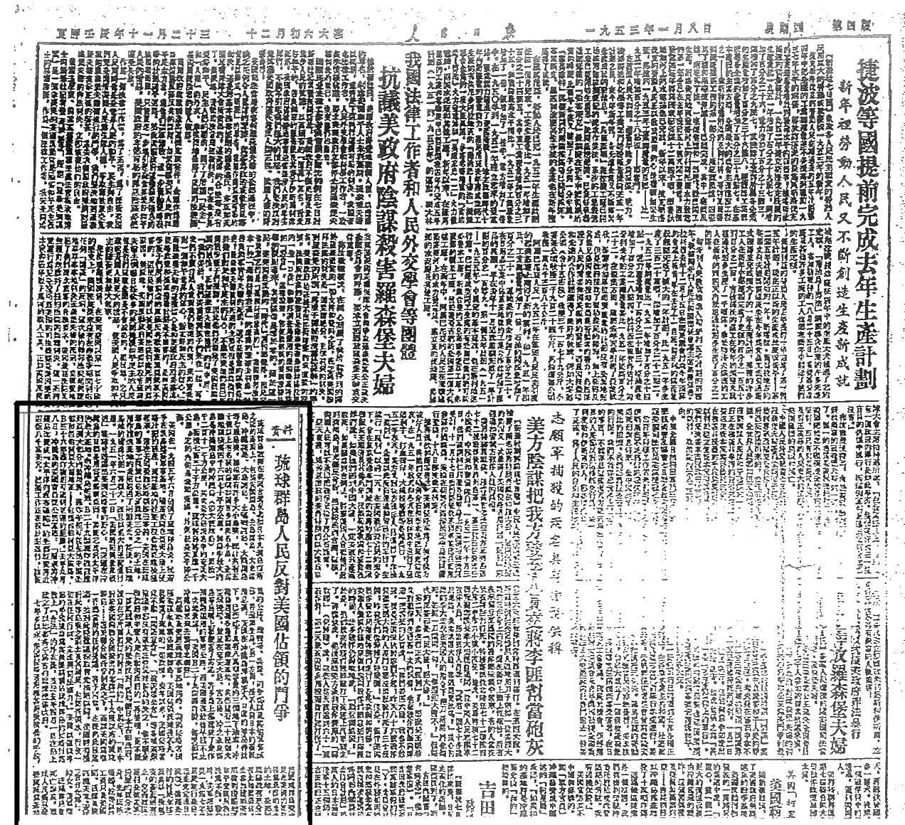
1953: On January 8, the People's Daily published by the Chinese Communist Party presents documentary material to explain a state of Okinawa and an American policy on Okinawa where the Senkaku Islands are clearly stated as belonging to Okinawa Prefecture.
 (Click to enlarge.)
http://www.jcp.or.jp/seisaku/2010/20101004_senkaku_rekisii/19530108_jn.jpg
1968: A committee for Far-East economy of the United Nations explores the East China Sea to find great reserves of crude oil.
1971: In April, Taiwan starts to claim its territorial jurisdiction on the Senkaku Islands.
In December, China starts to claim its territorial jurisdiction on the Senkaku Islands.
1972: On May 15, the U.S. returns administrative right of Okinawa Prefecture, including the Senkaku Islands, to the Japanese Government in Tokyo.
1972: On September 27, to establish diplomatic relationships between the two nations, Prime Minister of Japan Kakuei Tanaka talks with Chinese Premier Chou En-lai in Beijing. Tanaka raises the issue of the Senkaku Islands, but Chou does not follow it:
Tanaka: What do you think about the Senkaku Islands? Some people came to me for this issue, with various opinions.
Chou: I do not want to discuss the Senkaku Islands issue on this occasion. It is not good to talk about the the Senkaku Islands. As crude oil was discovered around the Islands, this issue has surfaced. Without crude oil there, anybody, including Taiwan and America, would take no notice of the Senkaku Islands. How many months will it take to appoint and send ambassadors to each other?
Ohira: We will take necessary measures as soon as possible, but it is impossible to specify in the joint communique the number of months within which we are to send ambassadors to each other...
(http://www.ioc.u-tokyo.ac.jp/~worldjpn/documents/indices/JPCH/index2.html )
(If Chou En-lai had had compelling evidence on China's right on the Senkaku Islands any Japanese would admit, he should have been able to simply show it to Japanese politicians, including Japan's P.M. Kakuei Tanaka and F.M. Masayoshi Ohira, even if on a private basis.)
1989: The so-called Tiananmen massacre occurs in Beijing where many students in demonstrations requesting democracy are attacked and arrested by the Chinese military and police.
After this incident, the Chinese Communist Government starts to educate Chinese children and students following an anti-Japanese policy. The Chinese leaders decide to present Japan as an enemy for students to attack. Students with any complaints to the Chinese Communist Party are not allowed to criticize the Party but encouraged to direct their anger to Japan.
2010: In the wake of violation of Japan's territorial water and the Japan-China agreement on fishing around the Senkaku Islands by a Chinese illegal trawler whose skipper is arrested but released by the Japanese Government, the U.S. Government confirms that the Japan-U.S. Security Arrangements apply to the Senkaku Islands.
In summary, no past documents and maps officially published in China in these 500 years do not state that the Senkaku Islands belong to China.
Rather, some such documents clearly exclude the Senkaku Islands from a relevant administrative territory of a publishing local government.
But, from the beginning, a Chinese empire had no clear distinction between administrative areas of the empire and tributary nations and between its defence line and its border. If people who belonged to an empire had lived in a certain place and there had been a need to protect them by force, the place would be regarded as its territory.
In neither this traditional context nor a modern concept, China has never established its territorial jurisdiction on the Senkaku Islands. Therefore, though the Islands are so far from Japan proper, they belong to Japan, since they were a familiar place for Japanese envoys and Okinawa envoys sailing to and back from China passing the Islands far more often than Chinese envoys did since 1372.
Now you know why the Senkaku Islands do not belong to China and Taiwan even when judging based on the Chinese claims. But, how do the Islands belong to Japan?
It is because the Senkaku Islands belong to Okinawa (Ryukyu). There is an island called Ishigaki-jima (the main island of the Yaeyama Islnads) where Okinawa residents or fishermen have lived from ancient days. And, there is a strong ocean stream from Ishigaki-jima Island to the Senkaku Islands. Fishermen in Ishigaki can easily reach around Senkaku to do their business. It is reflected in some old songs or stories of Okinawa.
In addition, the Chinese name of the Senkaku Islands meaning an island to angle for fish is reasonably thought to come after an old calling of the Islands by Okinawa/Ishigaki people. Okinawa people call the main Senkaku Island "Yoko"-jima (meaning a side island), or once called "Tsure"-jima, meaning an accompanying island the sound of which is similar to "tsuri" which is also similar to "tsuru" in Japanese, meaning angling for fish. There is no such material as to more reasonably expalian the origin of the Chinese name of the Islands meaning an island to angle for fish.
Put simply, the Senkaku Islands issue is not the one between Tokyo, the Senkaku Islands, and Shanghai but between the Yaeyama Islands, the Senkaku Islands, and Beijing. Check the map again!
ATTACHMENT I: China Admitted Japan's Senkaku in 1960
Some people in the world, including Americans, Chinese, Taiwanese, South/North Koreans, Russians, South East Asians, and Japanese nowadays seem to come to realize that the Senkaku Islands belong to Japan.
So, let's enjoy the confirmation!
 (Click to enlarge.)
As a special point to notice, the Beijing City Authority published a map indicating the Senkaku Islands as part of Japan in 1960. But, today, some Chinese are searching for this map to destroy it.
Some Chinese frequently visit book towns in Tokyo, looking for this map. Whenever they find it in an antiquarian bookshop, they buy it no matter how high the price tag is. They look like working under instruction of the Chinese Communist Government.
The portion of the map indicating the Senkaku Islands as part of Japan is as follows:
------------
Japanese government — assert the foundation for Japan's territorial dominion over the Senkaku Islands!
TAKAHANA Yutaka
Chairman, TEIKEI Inc.
...To begin with, both China and Taiwan have acknowledged the fact that the Senkaku Islands are Japanese territory. Under international law regarding "uninhabited remote territories" (the granting of dominion to countries with exclusive possession of lands that have no occupants), a cabinet decision on Jan. 14, 1895, assigned the five islands — including Uotsuri Jima — and three reefs that make up the Senkaku Islands to the prefecture of Okinawa as a result of a ten-year investigation there. Maps of every nation, and text books in China, acknowledged publicly that they were Japanese territory...
Instead of using the Chinese name of the island, Diaoyu Dao (釣魚島), the name is printed in the original Japanese as Uotsuri Jima (魚釣島). A line is drawn between Yonaguni Island and Taiwan in accordance with UN Convention on the Law of the Sea....
 (Click to enlarge.)
http://www.sdh-fact.com/CL02_1/53_S4.pdf
Note: Diaoyu Dao (釣魚島) is pronounced as "Cho-gyo Tou (jima)" in Japanese.
ATTACHMENT II: Chinese Name of Senkaku (Modified Japanese Calling)
The Chinese name and kanji expression of the Senkaku Islands is from an old calling of the main island of the Islands by old Okinawa people, according to a Japanese researcher.
The kanji expression in the Item 5 in the following figure is the the Chinese name and kanji expression of the Senkaku Islands which was derived from the original Okinawa expression through the steps.
 (Click to enlarge;
 Ref: http://senkakujapan.jugem.jp/?eid=8)
Chinese can speak English more easily than Japanese do, since the verb-object sequence is the same between the Chinese and English languages.
But, in Japanese, an object always follows a verb.
And, 500 years ago, Chinese fishermen living on the coastal areas of the Chinese Continent had no reason to sail to the Senkaku Islands 400 km (250 miles) off the shore to catch fish, risking their lives.
Only imperial envoys Chinese emperors sent would dare to sail 700 Km (438 miles) across the East China Sea to the main island of the Kingdom of Okinawa 500 years ago.
But, Okinawa people at the time were already sailing all over the Okinawa (Ryukyu) Islands that stretched over 800 Km. And, the nearest big Okinawa island to the Senkaku Islands is located just 190 Km (102 miles) away. They were really fishing around the Senkaku Islands 500 years ago.
It is also unthinkable that Okinawa People took the Chinese name of the Islands, meaning "angling for fish" as their own, too. It is more unthinkable that they took the Chinese name of the Islands, meaning "angling for fish" through changing the word order.
Therefore, a Chinese imperial envoy who dared to sail to the Kingdom of Okinawa, a tributary nation of the Ming Dynasty, for a diplomatic reason in the 16th century, must have adopted the Okinawa people's calling "Tsuri"-shima, namely an "angling" island. But, no Chinese fishermen could and would go and catch fish around the Senkaku Islands 400 km (250 miles) off the shore 500 years ago, since it was a dangerous voyage even for a Chinese imperial envoy using a big ship.
In addition, the concept of a border for a Chinese classic empire was different from the one for us, the modern people of today.
As the Kingdom of Okinawa was a tributary nation, the Ming Dynasty and later the Ching Dynasty had no need to define a border on the sea where any of their subjects lived. Ming and Ching had to protect their people from notorious Japanese pirates who ignored any border, if any, on the East China Sea. Okinawa never made war against its master empire in China. Naval security needed maps and definition of administrative/defence zones on the Chinese side, but it was not for claiming its border to its subject nation Okinawa.
If an emperor of Ming or Ching had pronounced its occupancy of the Senkaku Islands (or the "Cho-gyo-dai" Islands in Japanese for today's Chinese name of the Senkaku Islands) on the king of Okinawa, the king would have simply accepted it. But, there was even no such a need in the classic world of East Asia.
Finally, Okinawa was forced to officially belong to a Japanese samurai clan whose territory included islands north of the Okinawa Islands officially in 1611. The samurai clan Shimazu also belonged to Tokugawa shogunate in Edo (Tokyo). So, Okinawa was subject to both Japan and China nominally till the end of the Japan-Sino War in 1895, 27 years after the fall of the Tokugawa regime and the restoration of the imperial authority in Japan of 1868.
So, the "Uo-tsuri"-jima Island and other Senkaku islands have always belonged to Okinawa that belongs to Japan since 1611 (or since Okinawa people's ancestors' descending to the south from Japan proper thousands of years ago from a racial point of view, since the Okinawa language is one of dialects of the Japanese language, though very unique).
ATTACHMENT III: Treaty of Peace and Friendship between Japan and China
First of all, look at the map below that shows China's plan to expand its naval deployment and establish hegemony in the West Pacific region.
 (Click to enlarge.)
China has declared officially that it will have its naval fleets deployed from the west of Hawaii to the north of Australia, suppressing South Korea, Japan, Taiwan, the Philippines, Vietnam, Malaysia, and Indonesia.
Yet, as I introduced yesterday, the following is the pledge and the promise China made when Japan and China concluded "Treaty of Peace and Friendship between Japan and the People's Republic of China." Based on this treaty, Japan started lucrative provision of great financial and technological aid to China:
----------------
Treaty of Peace and Friendship between Japan and the People's Republic of China
August 12, 1978
[Article II]
The contracting Parties declare that neither of them should seek hegemony in the Asia-Pacific region or in any other region and that each is opposed to efforts by any other country or group of countries to establish such hegemony.
...
http://www.ioc.u-tokyo.ac.jp/~worldjpn/documents/texts/docs/19780812.T1E.html
----------------
But, China continued to build large-scale military capability, by increasing its military budget scores of times.
So, all the Japanese know that China is a liar and a betrayer. Whatever China officially announces, the Japanese people first doubt and suspect its truthfulness. The point is how many percentages China embeds truth in its official announcement and data, which is Japanese commonsense. It is also commonsense of Americans doing fair business in China.
But, American media elites lack this ability to doubt and suspect credibility of Chinese announcements and data.
When China first said that Japan Coast Guard ships violently hit a Chinese fishing boat around China's Senkaku Islands, American media elites should have first thought that truth must have been Japan Coast Guard ships were violently hit by a Chinese fishing boat around Japan's Senkaku Islands.
Now, will American media elites attend the Nobel Peace Prize ceremony to be held in Norway?
Anyway, let's confirm the lie the Chinese Communist Government tried to disseminate to the world, while the Japanese Government has refrained from making public the video showing violent actions of the Chinese fishing boat out of regard of honor of China.
The following is false and malicious illustration of the so called "collision" authorized and made public to the world by the Chinese Government trying to have Japan lose face:

Liars in the Chinese Communist Government can always find friends in The New York Times. This is a lesson we have to learn.
Anyway, truth is:
 (The blue ship putting the helm to port is of course the Chinese fishing boat. A Japan Coast Guard official on board the patrol ship being rammed took the video while being in danger of falling into the sea, though within the Japanese sea territory.)
*** *** *** ***
I think this is the most comprehensive time-line review on the Senkaku Islands ever written by a Japanese citizen in English.
You may advise The New York Times, Chinese Americans, and Chinese citizens/students in America to check it before discussing the matter.
*** *** *** *** *** *** *** ***
If you type in key words "Tokyo Station Reporter" in English Yahoo's Web Search, you would surely find "EEE-Reporter" in the first or second result page.
However, I was once a humble Sunday driver. So, I love to check cars and their license numbers even today.
Today, I found a white Chrysler car just in front of me on the street around Tokyo. Then, after turning around a corner, I saw a white Ford car. And then, a Benz, a big high-raised American car, and a compact yellow European car. In several minutes to see these foreign cars among hundreds of Toyota, Nissan, Mitsubishi, and other Japanese cars is not so usual.
In ancient China, a master is expected to put right clothes on, speak right words, and take a right action.
Christ Jesus said that a man without proper and respectful appearances would be thrown out of a honorable party of a lord.
Yet, after all, I could not understand what right or respectful car I should have owned.
But, I was once very satisfied when I checked an odometer to calculate a both-way travel distance and find it just 100 km after one Sunday drive from my own parking lot to/from Nikko where a notable temple for samurai hero Tokugawa Ieyasu is located.
(If you got stuck in a jam around Tokyo, it would take an hour to run 10 miles.)
That car should have been truly right one, though it was in the 20th century, since it was not an automatic car and not equipped with a car navigation system.
Yet, there was time when I had never thought that I would own and drive a car someday...
(http://www.youtube.com/watch?v=YhQCme2lJLo&feature=related
They said Misora Hibari truly sang well in a way no others could compete in Japan after WWII.
She sang, "As I am tomorrow to go up to Tokyo, I will have to win in any desperate way in the contest...as if to be King-General [of the Japanese chess]."
Today, people coming from Osaka to Tokyo take the Shinkansen super-express train or an air flight.
So, it may be time to have a look again at the Tokyo Station or the Haneda International Airport on Tokyo Bay...where I may be tomorrow.)
Luk 11:18 If Satan also be divided against himself, how shall his kingdom stand? because ye say that I cast out devils through Beelzebub.
Luk 11:19 And if I by Beelzebub cast out devils, by whom do your sons cast them out? therefore shall they be your judges.
Luk 11:20 But if I with the finger of God cast out devils, no doubt the kingdom of God is come upon you.